Kaali is mostly known for its meteorite craters, of which the biggest crater is surrounded by the eight smaller ones. The fall of the meteorite is dated quite differently. According to the latest knowledge, it must have happened during the second half of the Bronze Age or at the end of it, around 1600-1800 BC. To put it simply, the devastating effect of this event on already densely populated Saaremaa can be compared with the catastrophic results of a smaller nuclear bomb.
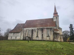
Kaarma Church is one of the oldest and architecturally most remarkable medieval sacred buildings on Saaremaa. Some researchers have suggested that the first stone church building—today’s sacristy—may have been erected already before the year 1227. In general, however, the oldest part of the stone church is dated to the mid- and late 13th century.
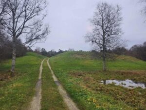
Kaarma hill fort is located220 m northeast of Kaarma church. It was built on a former river island, where the Põduste River has since split into two. This meant that the stronghold was surrounded by water on all sides. The stronghold is part of a ridge, with Kaarma church at its western end and sandy areas to the east. According to folklore, one of the most important cult sites of the islanders, Kaarma sacrificial hill, was located near the stronghold.
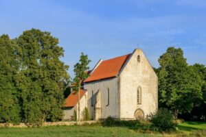
Karja Church is one of the oldest and most unique churches in Estonia, mentioned in written sources as early as 1254. It is located in the parish of the same name and is today dedicated to St. Catherine. About two kilometers northwest of the church is Karja Manor, from where the oldest Christian burials in the region from the 13th-14th centuries have been found.
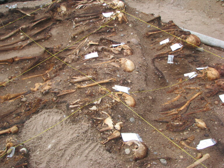
During construction works near the Karja manor in 1949, 18 skeletons with old artifacts were discovered. As it turned out, the construction works cut into an ancient cemetery that archaeologist Aita Kustin started to excavate in 1955. By this time, part of the cemetery was already under the building that was raised there later, but fortunately, it was still possible to excavate most of the burial site. The original size of the cemetery was approx. 400 m2. …
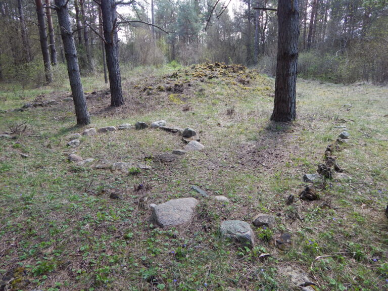
The burial site of Käku with its stone circle graves is located near the namesake Käku village in the parish of Kaarma in the middle of Saaremaa, 2.5 km NW from the Kaarma hill-fort and nearby church. The approximate dimensions of the burial site are 180 m (S-N) x 60-100 m (S-W). The whole area is densely covered with around 10-20 cm high round stone barrows, with a diameter of 5-7 m. A great part of the site has been destroyed or forested by now.
2002-2003 archaeological excavations were carried out on a burial ground known in the local tradition as Lepna Pestilence Hole (“Lepna Katkuauk”). The site is situated near the lower reaches of the river Maadevahe on a higher hill by the Iron Age seacoast. Therefore, it most likely marked the location of a prehistoric harbour site. …
The most well-known and researched Viking age grave site of Saarenaa in Piila is located in the middle of the island, in the former Kaarma parish. Archaeological works took place in Piila in two stages: the first excavations were carried out in 1987 (Vello Lõugas) and these were continued ten years later in the years from 1997-to 1998 (Mägi et al 1998). As is characteristic of other Viking age and late-Iron age grave sites of Saaremaa, different types of stone graves were found in Piila as well. This is also common in the neighboring areas of Saaremaa, for example in the west-Estonia, Finland, mid-Sweden, and Gotland. …
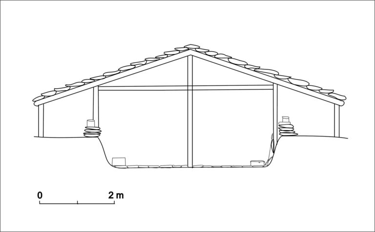
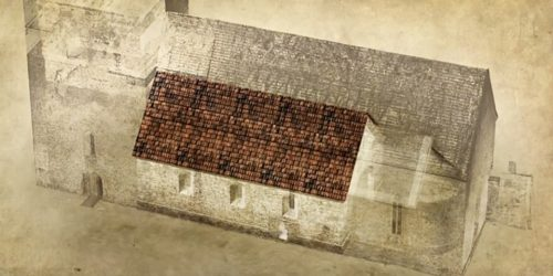
The Pöide church is one of the oldest stone churches in Estonia, probably built in the 1230s. Two massive post holes, discovered in the area right next to the stone church during excavations, indicate that a wooden building may have preceded the first stone construction. The first stone church, built in Romanesque style, was on considerably smaller scale than the one we can see today. However, shortly after the completion, the Romanesque church was rebuilt in Gothic style. …
Pöide hill-fort was one of the biggest prehistoric and medieval fortifications in Saaremaa. The present height of the walls is 5-6 m from the courtyard, and 10-11 m from the outside. Holes on the top of the hill-fort’s rampart date to the World War I, and had a military purpose. The hill-fort courtyard is 85 m long and 55 m broad, and in the middle of it is a hollow, one-time well. Next to the hollow is an elevation of big boulders, probably the remains of a building. The thickness of the cultural layer is 0.2-0.3 m in the middle of the courtyard. …
The stone burial site near Valjala, in the village of Rahu was discovered at the end of the 19th century. The rich collection of weapons, silver, and bronze items found there indicate that the people buried there belonged to a higher social class and had extensive contacts in both Scandinavia and the Baltic region. A total of approximately 3,000 items have been found in there, which has been dated to the Late Iron Age.
At the end of the 2000s, two boat burial graves were discovered during roadworks and were thereafter excavated by Marge Konsa and Jüri Peets in 2008-2012. The graves were characterized by both local and foreign features, and most of the warriors buried there were of Scandinavian origin. However, some of them may have been locals as well, as indicated by strontium analyses. It is commonplace to find graves near prehistoric harbour sites of Saaremaa, frequently with burials otherwise uncommon in Saaremaa. …
Tõnija, Põlluküla, and Rõõsa villages form one complex as a settled area. When analyzing the location of arable fields, the oldest settled points were located several hundred meters to the south of the so-called old Tõnija village and Rõõsa. The complex of Tuulingumäe-Saunamäe is between those aforementioned settled points, but somewhat closer to the later Rõõsa manor. It’s on the border of former arable fields and bog, in the higher zone filled densely with graves and probable other cult sites. …
Harbour sites from Viking Age Estonia have been archaeologically investigated mostly on the island of Saaremaa and excavated more thoroughly in four places – at Tornimäe, at Viltina, at Pällamõisa by the bay of Sutu, and most lately at Mullutu. …
Mägi, M. (2001). Probable cult site beside the Tõnija tarand-grave on the Island of Saaremaa. In: Archaeological Fieldworks in Estonia = Arheoloogilised välitööd Eestis 2000 (48−55). Tallinn: Muinsuskaitseamet.
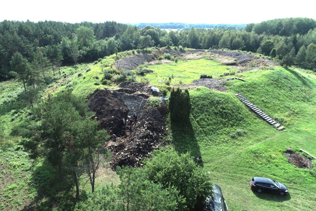
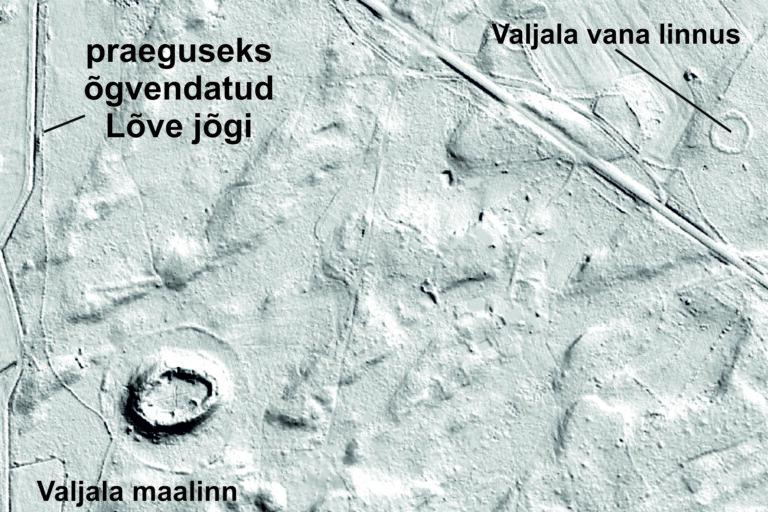
The large 12th-century hill forts of Saaremaa were built of dry-laid stone. One of the best preserved and researched examples is Valjala. The siege of the hill fort in 1227 was described by chronicler Henry of Livonia. According to the chronicler, there were both fortresses (castrum) and “towns” (urbs) in Saaremaa, and Valjala was the biggest of them.
700 m northeast of the Valjala hill fort lies a small, circular fortification just over 50 m in diameter. It was not very prominent – the fort’s rampart was essentially a large stone wall with a wooden fence on top. Minor excavations in 2022 uncovered pottery sherds and animal bones, and cleared out a section of the stone wall. 14C analyses dated the fort primarily to the 8th and 9th centuries.
The sacrificial site at Viidumäe was found by illegal detectorists who managed to almost completely loot it before archaeologists were able to register it in 2014. At least, several dozen photos of artifacts sold to the black market were shared, and have been proven useful for interpreting the site. A number of artifacts were also found during archaeological excavations. …
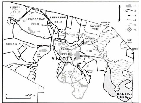
Viltina stone grave was excavated in 1940 due to the plan of constructing a Soviet military base in the southern Saaremaa. For this reason, the excavations were done hurriedly: in course of only two months, over 3200 m2 area was uncovered (by Artur Vassar and Marta Schmiedehelm). The burial site consisted of a larger stone grave without formal structure and surrounding smaller cairns. Some of the latter were not studied due to the lack of time. …
The southern coast of Saaremaa is well indented but flat, which is why there are not as many suitable locations for harbours as one may assume. A suitable area for landing was presumably in the vicinity of Asva, where quite deep buy reached inland, close to the arable lands. Here, at the site of the Bronze Age fortified settlement, another hillfort was erected in the 6th century and used until the 9th century. It was probably connected with a suitable harbour site somewhere in the vicinity. …